Chapter 2: Location and Extent
Balbharati solutions for Social Science Geography 10th Standard SSC Maharashtra State Board
Intext Questions | Q 1 | Page 13
Find the difference between the post-independence characteristics of India and Brazil.
Intext Questions | Q 2 | Page 13
The imperial power which ruled Brazil also ruled a part of India. Find out when that part of India achieved independence ?
Exercise | Q 1.1 | Page 13
Are the sentences right or wrong. ? Rewrite the wrong ones.
Brazil is mainly located in the Southern Hemisphere.
Exercise | Q 1.2 | Page 13
The sentence is right or wrong? Rewrite the wrong one.
Tropic of Capricorn passes through the middle of India.
right
wrong
Exercise | Q 1.3 | Page 13
Are the sentences right or wrong. ? Rewrite the wrong ones.
The longitudinal extent of Brazil is less than India.
Exercise | Q 1.4 | Page 13
Are the sentences right or wrong. ? Rewrite the wrong ones.
Equator passes through the northern part of Brazil.
Exercise | Q 1.5 | Page 13
Are the sentences right or wrong. ? Rewrite the wrong ones.
Brazil has a coastline along the Pacific Ocean.
Exercise | Q 1.6 | Page 13
Are the sentences right or wrong. ? Rewrite the wrong ones.
Pakistan is a neighboring country to the south east of India.
Exercise | Q 1.7 | Page 13
Are the sentences right or wrong. ? Rewrite the wrong ones.
The southern part of India is called Peninsula.
Exercise | Q 2.1 | Page 13
Answer in brief:
What problems did Brazil and India face after independence?
Exercise | Q 2.2 | Page 13
Answer in brief:
How are Brazil and India different from each other in terms of location?
Exercise | Q 2.3 | Page 13
Answer in brief:
Describe the latitudinal and longitudinal extent of India and Brazil.
Exercise | Q 3.1 | Page 13
Select the correct option
India’s southernmost point is known as :
Lakshadweep
Kaniyakumari
Indira point
Port Blair
SOLUTION
Indira point
It is a village in Nicobar district of the Andaman and Nicobar Islands in India. Kanyakumari is the southern tip of Cardamom Hills. Port Blair is the capital of the Andaman and Nicobar Islands. Lakshadweep is another island of the country in the south-east.
Exercise | Q 3.2 | Page 13
Select the correct option.
These two countries in South America do not share their border with Brazil.
chile-ecuador
argentina-bolivia
columbia-french guiana
surinam-uruguay
SOLUTION
Ecuador shares a border with Colombia and Peru and not with Brazil. Chile shares a border with Argentina, Peru, and Bolivia and not with Brazil.
Exercise | Q 3.3 | Page 13
Select the correct option.
Both the countries have ........... type of government.
Military
Republic
Communist
Presidential
SOLUTION
It is a type of government in which a state is ruled by representatives of the citizen body. The rulers of these countries are not monarchs. Brazil is a presidential type of government whereas India has a Parliamentary type of government.
Exercise | Q 3.4 | Page 13
Select the correct option.
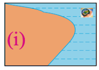
Which of the following shapes show the coastal part of Brazil correctly?

i
ii
iii
iv
SOLUTION

Exercise | Q 3.5 | Page 13
Select the correct option.
Which of the following shapes show the coastal part of India correctly?

i
ii
iii
iv
SOLUTION

Exercise | Q 3.6 | Page 13
Select the correct option.
Considering hemisphere, which shape correctly represents the hemisphere in which India lies?

i
ii
iii
iv
SOLUTION

India lies in the Northern and South Hemisphere.
The first figure shows the Eastern region. The second figure shows the Southern region. The third figure shows the Northern region. The fourth figure shows the Western region.
Exercise | Q 3.7 | Page 13
Select the correct option.
Considering the hemisphere, which correctly represents the hemisphere in which Brazil mainly lies?

i
ii
iii
iv
SOLUTION


